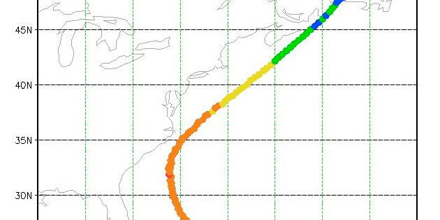
Chapel Hill, NC—As Hurricane Earl strengthened and headed toward North Carolina’s coast, RENCI researchers tracked it’s every move with a Weather Research Forecast (WRF) model that plotted the storm’s course on a grid, with each point in the grid representing a 3-kilometer-by-3-kilometer box.
The model’s 3 km resolution is significant because it means scientists did not need to use parameterization schemes—a method used to predict the collective effects of many clouds that might exist within a grid box—in the model. Parameterizations often result in models that underestimate a storm’s intensity, said Brian Etherton, a senior atmospheric scientist at RENCI. Storm intensity also affects the storm track, so RENCI’s model predicted a somewhat different track than the models run by the National Center for Environmental Prediction (NCEP), the National Weather Service division that provides most of the commonly used forecasting products.
Hurricane Earl animation
[pro-player width=’630′ height=’353′ repeat=’true’ type=’video’]http://www.renci.org/wp-content/uploads/2010/08/2010083100.mp4[/pro-player]
“Our model shows Earl coming closer to the coast than the NCEP forecasts,” said Etherton as the storm headed north and west from the Caribbean. “The National Weather Service offices in Raleigh, Wilmington and Morehead City are all looking at our output. It is a research tool that we can compare to other models. When the storm is over we can evaluate our model and its value in predicting the track and intensity of Earl.”
In addition to the WRF model, RENCI scientists modeled coastal storm surge and waves associated with Hurricane Earl. The models showed storm surge, or the height of water pushed inland by the storm, of 2 – 4 feet on North Carolina’s Outer Banks. During the life of a tropical storm, all the models run twice a day using RENCI’s Dell/Intel supercomputer Blue Ridge, which is capable of 8 trillion calculations per second.
In the end, Earl brushed the Outer Banks and caused little damage. RENCI’s model predicted the storm heading close to the coast about four days earlier than most commercial models, according to Etherton, and also predicted the storm would reach North Carolina as a Category 3 storm earlier than other models.
“Our models did have Earl heading toward the Outer Banks when other models had it somewhere between Bermuda and the coast,” said Etherton. “That had an effect in the forecasting community.”
Although Earl is long gone, Etherton stressed that the hurricane season is only half over and that more storms could head toward North Carolina before the season ends Nov. 30. He is tracking Tropical Storm Igor, still far out in the Atlantic, and predicts that two additional storms—which would be named Julia and Karl—could form by Sept. 14 and threaten the East Coast.


