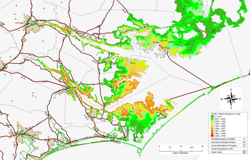
Storm surge inundation from Hurricane Isabel (2003) with evacuation routes and emergency management shelters (green dots).
While generating precise and accurate storm surge and atmospheric predictions during a tropical cyclone (a hurricane) is important, so too is knowing the best way to safely evacuate and shelter the large numbers of people threatened during these events.
RENCI Senior Research Scientist and Oceanographer Brian Blanton, PhD, recently launched an National Science Foundation (NSF) funded project that will use a suite of physical models for coastal storm surge, terrestrial precipitation and water routing, and mesoscale meteorology to calculate probable impacts of tropical cyclones and how these impacts affect coastal evacuation and sheltering plans.
The modeling system will determine statistical water levels, winds, precipitation, and river drainage during tropical cyclone events by simulating likely hurricane tracks using the models ADCIRC, CREST, and WRF. RENCI supercomputers will compute the statistics, which will require about 1 million hours of compute time to produce. RENCI will also integrate data management middleware into the modeling system in order to automate data management, data sharing and storage.
“Our idea is to create an integrated system that combines models for the natural physical hazards within hurricanes with models for evacuation and sheltering plans. This system will describe the probabilities of storm surge, wind speeds, and river flows under a variety of likely hurricane scenarios and how these probabilities can help us recommend optimal, risk-balanced evacuation route and shelter planning,” said Blanton. “We think this will mean more information and context that can be used to improve evacuation plans and ultimately to modify plans based on storm conditions as they unfold.”
The project is designed to improve current evacuation models used by emergency managers to decide who to evacuate and when. Current evacuation models are based primarily on “clearance time,” or ensuring that evacuees are on the roads for the shortest amount of time possible. These models do not take into account what populations are at most at risk, potential for injury or loss of life, or other social factors.
The new modeling system will evaluate planning options and determine the most optimal evacuation routes that optimize the aggregate risk to coastal populations, instead of minimizing only clearance times. They will take into account the spatial and physical characteristics of the natural and built environments and the population characteristics of the threatened coastal areas. The goal is to use a consistent approach to integrated probabilistic modeling that will inform and improve evacuation models, initially for North Carolina coastal communities.
Partners on the project include researchers at the University of Delaware, Cornell University, the State University of New York (SUNY) at Stonybrook, and the University of Oklahoma. Funding is provided through the NSF’s Interdisciplinary Research in Hazards and Disasters Science, Engineering, and Education for Sustainability program (Hazards SEES). The North Carolina Department of Public Safety, within which is the Emergency Management division, is also a participant in the project.
For more information on all of RENCI’s work with Coastal Hazards Modeling, visit our project page.


