The four organizations that comprise RENCI at UNC Charlotte have been awarded $300,000 from the National Science Foundation to study how land owners’ decision processes affect forest persistence.
Recognized for their forecasts of growth patterns in the Charlotte Metro region, The four partners in RENCI at UNC Charlotte – already recognized for their forecasts of growth patterns in the Charlotte Metro region – are UNC Charlotte Center for Applied GIScience (CAGIS), the UNC Charlotte Infrastructure, Design, Environment and Sustainability Center (IDEAS), the UNC Charlotte Visualization Center (VisCenter), and the UNC Charlotte Urban Institute. The NSF award will allow researchers with the four groups to use data and modeling techniques developed in their previous work forecasting growth and development to look at why natural areas persist.
The grant was one of 17 awards made to pilot urban research projects and covers a 30-month period beginning Sept. 15.
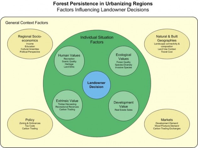
The project has both basic research and community engagement components. In the basic research component, researchers will build sophisticated models of the factors influencing landowners’ decisions to maintain or develop forested land. The factors to be explored include economically measurable ones such as land development value, timber harvesting value, and potential carbon trading value, and more intangible ones, such as ecosystem intrinsic value, cultural and human values. A sampling of landowners with forested lands will be invited to participate in interviews and surveys to elicit data about the relative weight given to various factors in their decision-making.
The community engagement component is intended to ensure that the results of the research will have real-world utility. It will give regional stakeholder organizations the opportunity to consult with the researchers on what factors to include in the model, how to identify landowners willing to participate, and how the results may be used.
RENCI researchers Ross Meentemeyer (CAGIS), Jean-Claude Thill (IDEAS), and William Ribarsky (VisCenter) are directing the research in collaboration with Chunhua Wang of UNC Charlotte’s department of geography and earth sciences, and Todd BenDor of UNC Chapel Hill’s department of city & regional planning. Meentemeyer will head the interdisciplinary team and provide landscape ecology and spatial modeling expertise; Thill is a leading urban systems modeler; Ribarsky will focus on visual analytics tools to support the modeling and the landowner surveys; Wang is an environmental economist; and BenDor is an authority on land use planning and public policy.
The UNC Charlotte Urban Institute will lead the community engagement effort, convening community partner meetings and conducting the landowner interviews and surveys. Community partners currently include the USDA Forest Service, the U.S. Fish and Wildlife Service, the North Carolina Wildlife Resource Commission, North Carolina State University Forestry Department Extension, Gaston County Cooperative Extension, Catawba Regional Council of Governments, Centralia Council of Governments, Catawba Lands Conservancy, Land Trust for Central North Carolina and Nations Ford Land Trust.
By the grant’s completion, the team hopes to develop a sophisticated model that will give land planners a very valuable and versatile tool with the ability to look into the future and to see with greater clarity the effects of a multitude of potential future conditions and policy decisions.
For the full story (pdf)


