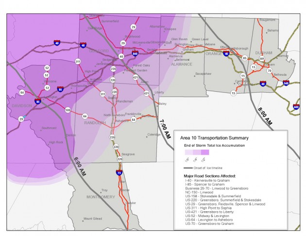
A prototype graphic display of ice storm information lets the user see how much ice will accumulate and what roads will be affected.
A school snow day often leaves kids jumping for joy and their parents scrambling to readjust their work schedules.
But what about the people who make the decision to cancel classes? They are usually school transportation officials, who analyze changing weather conditions and gather information on road conditions, and school district administrators, who make the final decision. Most of the time, they have no training in meteorology or emergency management, yet the safety of thousands rests in their hands during winter weather emergencies.
Through a project called Weather for Emergency Management, or WxEM, RENCI and its partners are working to understand the dynamics of school closing decisions and are testing new technologies—including easy-to-understand visual presentations of weather data and real-time collaboration tools—so that school officials will be able to make closing decisions using the best, most relevant and up-to-date information.
“If you want to turn information into knowledge and then into action, you need more than just raw data,” said Ken Galluppi, RENCI’s director of disaster and environmental programs. “The information needs to be presented in the context of what’s important. If I’m the transportation director at a school, I need to know more than the weather forecast. If the forecast calls for snow or ice, I need to know how it will affect road conditions and for how long. And I need to be able to get to that information quickly in a format that is easy to understand.”
WxEM: decision support for emergencies
The National Weather Service provided RENCI with $400,000 for year one of the WxEM project. The NWS is a collaborator on the project and expects it to help them understand how emergency management communities operate during weather emergencies and rapidly develop new tools that will lead to more informed decisions and more effective actions by emergency officials in schools, government agencies and the private sector.
RENCI and partners at East Carolina University plan to tackle the problem in three ways: by conducting research with people who deal with emergencies to understand their needs and how they operate during emergencies; by rapidly prototyping and testing new technologies that can make weather data easier to decipher and allow emergency managers to access the most useful information for their situation; and by introducing new collaboration tools to emergency management communities so that knowledge can easily be shared.
Burrell Montz, chair of the geography department at ECU, leads the effort to collect data on how emergency managers make decisions, with the focus in year one on school district emergency decision makers. The ECU team is conducting surveys with school emergency personnel to determine what information they use to make closing decisions, how they pull information sources together, who they talk to during the decision making process, and what kinds of information trigger actions.
New prototypes, new collaboration tools

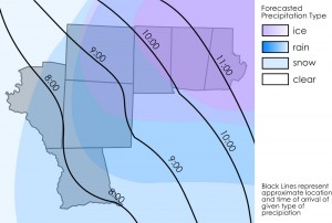
Another prototype graphic designed to let school officials know when precipitation will start in different locations and whether it will be snow, ice or rain.
RENCI leads the rapid prototyping work and the effort to introduce new collaboration tools to emergency response communities. As a first use case for their work, the research team chose K-12 schools and the decision making process involved in winter weather school closings. School decision makers, according to Galluppi, have few decision support tools.
“In the schools, the people making closing decisions usually are not trained as emergency managers, they don’t have a system for sharing information and they don’t have tools that help them interpret the impacts of severe weather,” Galluppi said.
This winter, the research team will introduce school decision makers to visual models that display key facts about an impending winter storm: when it will start, how long it is likely to last, and whether the precipitation will be snow, ice, rain, or some combination. By looking at the visualizations, a school decision maker will be able to easily figure out when a storm will start and what kind of precipitation will fall at what time.
The RENCI team also will introduce school emergency planners to The Big Board, a Web-based collaboration tool that starts with a high-resolution aerial map of an area and allows users to attach comments, photos and other information to specific locations on the map. Developed by RENCI Senior Research Software Developer Jeff Heard, the Big Board will allow officials in the field to post information to a Web space using a smart phone or laptop, where anyone with an Internet connection will be able to see it.
Currently, collaboration on school closing decisions means people must drive around to check road conditions and call in their reports while someone jots down the information in a notebook, said Galluppi. By using the Big Board, information can be shared with a much larger group and in real time, he said.
The RENCI team expects to introduce its decision support tools to selected schools in January and will conduct several simulated winter weather emergencies with school officials using data from past years. In the spring, RENCI will present its findings on the winter weather tools to the National Weather Service and will then turn its attention to decision support tools for tropical storms.
###
 RENCI WxEM project supports the Innovate@Carolina Roadmap, UNC’s plan to help Carolina become a world leader in launching university-born ideas for the good of society. To learn more about the roadmap, visit innovate.unc.edu.


