
APSViz provides critical, high-resolution coastal hazards information to expedite decision-making and productivity
On September 28, 2022, Hurricane Ian made landfall along the west coast of Florida as a Category 4 hurricane–the strongest Category 4 hurricane to hit the region since Hurricane Charley in 2004–causing substantial damage from strong winds and the resulting storm surge and wind waves. Hurricane Ian then crossed the Florida landmass, emerged into the Atlantic Ocean, strengthened back into a weak hurricane, and made a second landfall on the South Carolina coast. According to the National Oceanic and Atmospheric Administration (NOAA), the damage caused by Hurricane Ian in its two landfalls ranks it as the third-costliest weather disaster in U.S. history. This major event required multiple state and local agencies to prepare for significant storm impacts, assess potential damages, and plan for post-storm recovery activities.
Over the past three years, the Renaissance Computing Institute (RENCI), a data science research institute at UNC-Chapel Hill, has been developing a state-of-the-science, cloud-ready data engine, visualization, and information delivery system called APSViz. As a core project within the Department of Homeland Security’s Coastal Resilience Center at UNC-Chapel Hill, APSViz disseminates real-time coastal hazards information and enhances research productivity by making it much easier to understand computer simulations and predictions of coastal hazards.
During significant coastal events like Hurricane Ian, APSViz has the potential to serve as a key resource for state and federal stakeholders and response teams. By providing critical, real-time, and high-resolution information to assist officials in making decisions for timely evacuations and other preventative measures, APSViz could add substantive value to response strategies and reduce negative impacts from tropical cyclones.
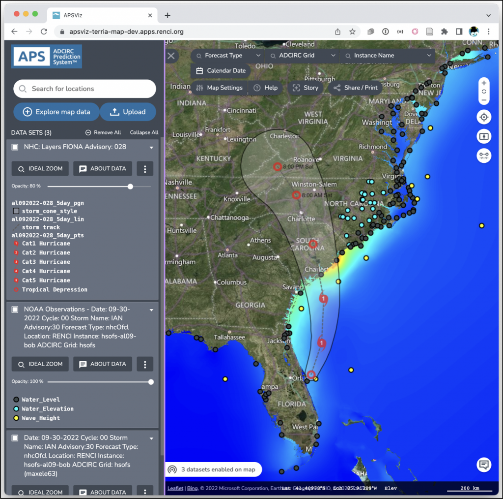
The primary computer model for coastal storm surge and wind wave simulation is ADCIRC, co-developed by researchers at UNC-Chapel Hill and the University of Notre Dame, along with other academic, federal, and industry collaborators. Originally developed for retrospective simulation of past meteorological events, ADCIRC has been increasingly used for forecasting and predicting weather-driven impacts on the coastal environment. ADCIRC is the core computational model in the ADCIRC Prediction System (APS). APSViz is a “window” into these real-time forecasting activities and will provide critical information to federal and local decision-makers to help mitigate damages, injuries, and fatalities caused by major coastal events.
Given the pressing need for proactive hurricane preparedness, APSViz has been developed by RENCI’s Earth Data Science group, leveraging RENCI’s expertise and resources in data management, database and geospatial technologies, and, in particular, the cloud technology, Kubernetes. In the APSViz context, Kubernetes manages containerized processes in a computing resource pool, schedules processes in the appropriate order, identifies needed resources, and disseminates results to both web-mapping frameworks and storage.
The entire APSViz infrastructure is deployable to Amazon Web Services’ (AWS) Elastic Kubernetes Service, which will be used during active hurricane events that pose a substantial threat to the U.S. coast. Containers for new products are easily deployed to the Kubernetes workflow, enabling rapid extension and customization of APSViz. Additionally, the APSViz user interface is highly flexible, allowing for user-driven control of the mapping view (i.e., color maps, data ranges, etc.). Moreover, it is relatively straight-forward to incorporate other computer models into APSViz, allowing for further customization based on user needs.
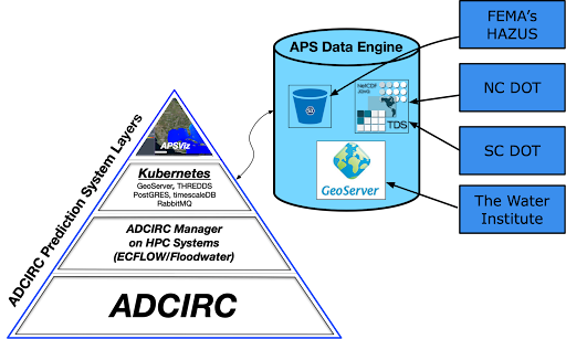
APSViz is under continuous development to further increase its utility for storm surge and wind wave forecasting, streamlining the delivery of critical information to the people who need it most. A key component to the infrastructure is the availability of critical data layers (such as coastal water inundation onto land) to be accessed by external end users for input into their own decision support systems. In other words, APSViz is not just about visualization on the web, but also making a variety of products more generally available through well-known access methods, including AWS S3 buckets, the widely used GeoServer, and THREDDS data servers (Figure 2). Currently, DHS/FEMA, the North Carolina Department of Transportation, and The Water Institute of the Gulf extract APSViz layers from the data engine for use in their own analysis systems.
“The APSViz infrastructure is enabling us to develop our own forecasting visualization applications much more rapidly. It is saving a substantial amount of application development time which we can invest in improving other parts of our systems,” said Zach Cobell, senior computational scientist at The Water Institute.
According to NOAA, hurricane activity predictions for the 2023 season indicate a relatively normal number of named storms for the North Atlantic ocean, which typically gets about 14 named tropical events each year. The 2023 North Atlantic season will be a critical proving ground for the APSViz infrastructure as it becomes more generally available at apsviz.adcircprediction.org.