Overview
 Storm surge, a primary cause of coastal flooding during tropical and extratropical storm systems, occurs when a storm’s winds push water toward land. The water mass encounters shallower water as it moves toward shore and increases in height. Additional factors like a storm’s pressure and the waves generated by storm winds also contribute to the total surge that impacts a coast.
RENCI’s Earth Sciences and Software group conducts research into coastal hazards and risk through a suite of diverse yet synergistic projects, with nationally recognized subject matter experts. Collaborations with universities, federal agencies, and industry have resulted in research outcomes and applications that are advancing fundamental science as well as having substantive impacts on decision makers in coastal hazards and risk.
The primary computational tool is the storm surge and wind-wave model ADCIRC, co-developed at the University of North Carolina at Chapel Hill and the University of Notre Dame. ADCIRC is used for fundamental research in coastal oceanography, engineering and flood protection design studies, and for coastal hazard assessments for the Federal Emergency Management Agency’s National Flood Insurance Program.
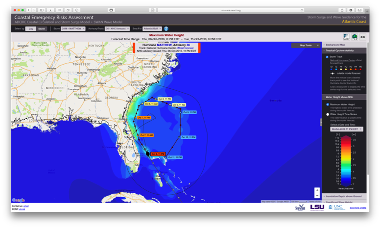
Working with academic, federal, and commercial collaborators through the DHS-funded Coastal Resilience Center, RENCI operates and maintains the North Carolina Forecast System, an advanced, autonomous computational system based on the Adcirc Surge Guidance System (ASGS). It runs in near real-time during active tropical cyclones that threaten any part of the US east and Gulf of Mexico coasts. ASGS manages the entire computational process, with its output (water levels, winds, and wave heights) provided to the nc-cera.renci.org web page for dissemination and public access. Data files, including standard model output files and GIS shapefiles, are posted on RENCI public data servers.
RENCI’s Role
The North Carolina Forecast System connects the surge and wave model ADCIRC+unSWAN with several atmospheric prediction models, including the National Centers for Environmental Prediction’s operational weather forecasting model and tropical cyclone forecast advisories from the National Hurricane Center. Hydrological river discharges are imposed as boundary conditions on the upper Tar and Neuse Rivers.
The system runs on RENCI’s Dell cluster, Hatteras, two times a day under normal operations and on four times a day during the tropical, cyclone events. The primary outputs of the system (water level and wave height) are published as graphic images to the website nc-cera.renci.org, where end users such as state and county emergency management managers can access the forecast results to help in their decision making process.
- ADCIRC+unSWAN models depth-averaged circulation, water level, and the irregular, wind-driven wave field, coupling the long- and short- wave fields using a common unstructured model grid. The coupling occurs in real-time, through exchange of water level and currents from ADCIRC to unSWAN, and wave radiation stresses from unSWAN to ADCIRC.
- Current and recent projects using ADCIRC and related software include:
- Data access and visualization of storm surge models for NOAA’S National Hurricane Center
- Statistical Modeling of storm surge for North Carolina
- Optimal, risk-based evacuation routing for coastal North Carolina during hurricane events
- Storm surge hazard assessment for New Jersey waste water facilities
- Application of the ADCIRC modeling system for the North Carolina Sea Level Rise Impacts Study
Project Team
- Brian Blanton (Project Leader)
- Chris Lenhardt
- Lisa Stillwell
- Chris Calloway
Partners
- Cornell University
- University of Delaware
- State University of New York, Stonybrook
- University of Oklahoma
- North Carolina State University
- Argonne National Labs
- Coastal Resilience Center
- NC Division of Emergency Management
- UNC-Chapel Hill Institute for Marine Sciences
- US Army Corps of Engineers, Field Research Facility
Funding
- National Science Foundation
- NOAA/NHC
- Department of Homeland Security/Office of University Programs
- State of North Carolina
- FEMA
Resources
- ADCIRC website
AdcircViz: A Visualization Application for Distributed ADCIRC-based Coastal Storm Surge, Inundation, and Wave Modeling
Overview
To broaden the distribution of ADCIRC-based results to a wider audience of users, RENCI has developed a MATLAB-based graphical user interface, called AdcircViz, to provide uniform access to the collection of ASGS forecast outputs. The application helps both ADCIRC experts and decision-makers, including forecasters at the National Hurricane Center (NHC) in Miami, Florida, to see what geographical regions are currently covered by ADCIRC, which systems are running for a specific hurricane forecast advisory, and access, display, and analyze the real-time ADCIRC prediction output.
AdcircViz provides consistent display of model results, inter-comparison of time series output at user-selected locations, animation of time-dependent output fields, and export to GIS shape files. The data grid and AdcircViz application can be applied to any model whose output files are CF-UGRID compliant and posted on a THREDDS data server. This software will enable the NOAA National Hurricane Center (NHC) to access, display, and analyze ADCIRC-based simulation output. The NHC used ADCIRC model outputs for the first time during the 2014 hurricane season, using AdcircViz.
RENCI’s Role
RENCI has developed the AdcircViz application and is working with the National Hurricane Center to enable them to use AdcircViz in their operational storm surge forecasting group. This will allow them to access and use ADCIRC-based storm surge results as additional guidance in their forecast decision making process.
RENCI Team
Brian Blanton (PI)
Chris Calloway
Partners
Rick Luettich, UNC Coastal Resilience Center and Institute of Marine Sciences
Funding
Dynamic Modeling and Evaluation of Coastal Evacuation Plans
Overview
While generating precise and accurate storm surge and atmospheric predictions during a tropical cyclone (hurricane) is important, so too is knowing the best way to safely evacuate and shelter the large numbers of people threatened during such events. This project will extend previous research into computer models for evacuation and sheltering plans by incorporating probabilistic ensemble methods to characterize uncertainty in hurricane forecasts.
Current evacuation models are used to inform emergency managers on who to evacuate and when, but these models are based primarily on “clearance time,” or ensuring that evacuees are on the roads for the shortest amount of time. The models do not take into account what populations are at most at risk, potential for injury or loss of life, or other social factors. These new models optimize evacuation plans and routes by minimizing the aggregate risk to a coastal population, instead of only minimizing clearance times. The goal is to use a hazard-consistent approach to integrated probabilistic modeling that can be used to inform and improve evacuation models for NC coastal communities. This new modeling will take into account the spatial and physical characteristics of the natural and built environments and the population characteristics of the threatened coastal areas.
RENCI’s Role
RENCI’s coastal storm surge modeling work using ADCIRC will form the basis of a comprehensive tropical cyclone impacts modeling system that integrates coastal oceanographic processes with mesoscale meteorological and hydrological processes. This physical modeling system will determine probabilistic water levels, winds, precipitation, and river drainage during emergency events. RENCI supercomputers will be used to compute the models, which will require large compute-resources to support. RENCI will also develop an integrated approach to data management and delivery of model output using the iRODS data management middleware.
RENCI Team
Brian Blanton (Co-PI)
Partners
- University of Delaware (Lead)
- Cornell University
- State University of New York (SUNY), Stonybrook
- University of Oklahoma
Funding
National Science Foundation’s Interdisciplinary Research in Hazards and Disasters Science, Engineering, and Education for Sustainability Program (Hazards SEES)
AdcircLite-NC: Rapid evaluation of storm surge and wave forecasts using the Notre Dame Surrogate Forecast Generator
Overview
Urgent and on-time forecasting of potential and imminent disasters is needed in the days and hours before a tropical cyclone (hurricane). To aid decision makers in both pre- and post-disaster efforts, forecast information must be available within the typical forecast cycle, and as early as possible. In the case of coastal storm surge and wave forecasting, the numerical models used for forecasting need to accurately represent both the physical processes and the complexity of the coastal region. This constraint imposes a high spatial and temporal resolution on the model. Consequently, the forecast simulation can be resource-intensive and potentially delay delivery of the needed information beyond the decision making time window.
This project will enable rapid coastal hazards assessments by implementing a response surface method for computation of statistical forecasts. The method uses a database of probabilistic hurricanes and storm surge/wave responses computed for the North Carolina Floodplain Mapping Program, which were used to develop the next-generation coast flood insurance rate maps for FEMA.
RENCI Team
Brian Blanton (PI)
Partners
Andrew Kennedy and Alexandros Taflanidis, University of Notre Dame